
Dedicated to leading the next discoveries of critical minerals
Experts in Exploration

Baseline Geophysics is a Canadian geophysical consulting and contracting company providing services to the mineral exploration industry. The company has expertise in the acquisition, processing, modelling, and interpretation of ground and borehole geophysical surveys.
Exploration, made clear
Our Principles
Our approach is grounded in technical expertise, operational excellence, and a deep understanding of our clients’ needs. We design tailored solutions aimed at meeting and, often exceeding, project expectations. Supported by customized methodologies and delivered by highly qualified personnel, our work integrates innovation and reliability as core principles.
Marc Auclair, P.Geo., géo.
President, Geophysicist
Applied geophysicist specializing in electrical and electromagnetic methods. His experience spans the full spectrum of activities, from field operations to technical project leadership. A versatile leader, he is recognized for his critical thinking and his ability to deliver effective, innovative solutions.


Our experience includes work in recognized districts across Canada, the United States, the Middle East, East and West Africa, Eastern Europe, and Central Asia. This geographic diversity reflects our ability to operate effectively across a wide range of geological, climatic, and operational environments.
Global know-how. Delivered
Our team brings together highly experienced professionals with decades of hands-on field experience. Our experts have worked around the world in some of the most demanding environments, contributing successfully to projects in numerous major mining camps. This practical, international experience enables us to deliver robust, realistic technical solutions tailored to the specific challenges of each project, wherever mineral exploration takes place.


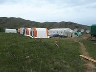
All Terrain Crews
Baseline Geophysics relies on customized methodologies tailored to varying field conditions and the geological context of each project. This personalized approach enables the highest standards of quality while maintaining health and safety as absolute priorities at every stage of the work.
Health and safety, without compromise

Our expertise
Baseline Geophysics specializes in ground, borehole, and drone-based surveys for mineral exploration.
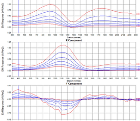
Electromagnetics (EM)
Detect and define geological conductors such as massive sulphides, graphite, and iron formations.

Induced Polarization (IP)
Define conductive or resistive ore bodies, metallic sulphides, faults and shear zones.

Magnetics and Gravity
Map bedrock geology, structural features, and magnetic or dense ore bodies.


Baseline Geophysics supports you throughout your exploration campaign,
from field data acquisition to the definition of mineral deposits.
-
Ground, borehole, and drone surveys
-
Line cutting and preparation
-
Survey planning
-
Airborne survey management
-
Quality control (QA/QC) and processing
-
3D modelling and inversion
-
Mapping and interpretation
-
Target generation
-
Compilation of historical datasets
-
Research and development
High-quality,
turnkey solutions
A comprehensive service offering,
built on rigor and innovation

Our Technologies
Baseline Geophysics is equipped with state-of-the-art instrumentation and software, delivering innovative methodologies.
Ground Geophysics
High-precision mapping of mineral potential to depths of up to 500 m using induced polarization, electromagnetics, gravity, and magnetics.
-
IP in 3D, 2D, and gradient configurations
-
EM in HLEM (Max-Min), VLF, and TEM configurations.
-
Surface magnetics and gravity

Borehole Geophysics
High-density data acquisition along drillholes, extending beyond the depth limitations of surface surveys using borehole geophysical methods.
-
Borehole logging
-
Radial and crosshole IP
-
Mise-à-la-masse IP

Modelling and interpretation
We operate a suite of high-performance software and computing systems for the processing and inversion of complex datasets.
-
Oasis Montaj
-
Seequent VOXI
-
EMIT Maxwell
-
RES2D / RES3DINV


Consulting
Baseline Geophysics supports its clients with survey planning, enhancement of acquired data, and the compilation of historical datasets.
Data processing
-
Quality control
-
Data corrections
-
Georeferencing
-
Data levelling
-
Data merging
Advanced Analysis
-
Spatial derivatives
-
Frequency domain filtering
-
Multi-parameters grids
-
Kimberlite and porphyry detection
-
Contact tracing
-
Identification of faults and folds
Mapping
-
Contour maps
-
Pseudosections and profiles
-
Vertical sections
-
3D isosurfaces
-
Depth sections
3D Modelling
-
Maxwell Plate (EM)
-
VOXI (IP/EM/MAG/GRAV)
-
RES2DINV (2D-IP)
-
RES3DINV (3D-IP)
-
Constrained Inversions
Interpretation
-
Lithological interpretation
-
Structural analysis
-
Target generation
-
Borehole planning
Compilations
-
Digitization of old data
-
Property wide data searches
-
Multi-survey interpretations
-
Integration of geological data

Send us a message!
93-4740 Dalton Drive NW
Calgary, AB
T3A 2H4
+1 613 407 7524
